
File:Galunggung.jpg
Size of this preview: 640 × 353 pixels.
| |
This is a file from the Wikimedia Commons. Information from its description page there is shown below.
Commons is a freely licensed media file repository. You can help. |
| Description |
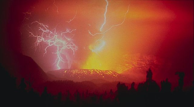
English: United States Geological Survey photo of 1982 eruption of Galungung (with lightning strikes). Cropped. This stratovolcano with a lava dome is located in western Java. Its first eruption in 1822 produced a 22-km-long mudflow that killed 4,000 people. The second eruption in 1894 caused extensive property loss. The slide depicts a spectacular view of lightning strikes during a third eruption on December 3, 1982, which resulted in 68 deaths. A fourth eruption occurred in 1984. Source Caption: Galunggung, Indonesia;07.25 S 108.05 E;2,168 m elevation
Español: United States Geological foto de la Encuesta de 1982 la erupción de Galungung (con un rayo cae). Recortada. Este volcán con un domo de lava se encuentra en el oeste de Java. Su primera erupción en 1822, produjo a 22 km de largo flujo de lodo que mató a 4.000 personas. La segunda erupción en 1894 causó la pérdida de propiedad extensiva. La diapositiva muestra una vista espectacular de la caída de rayos durante una tercera erupción el 3 de diciembre de 1982, que resultó en 68 muertes. La erupción de un cuarto se produjo en 1984. Leyenda Fuente: Galunggung, Indonesia; 07,25 S 108,05 E; 2.168 m de altitud
|
| Date | 3 December 1982 |
| Source | image from NOAA website |
| Author | R. Hadian, U.S. Geological Survey |
Location
|
Camera location |
|
This and other images at their locations on: Google Maps - Google Earth - OpenStreetMap | ( Info) |
|---|
 |
This image is in the public domain because it contains materials that originally came from the U.S. National Oceanic and Atmospheric Administration, taken or made as part of an employee's official duties.
|
 |
File usage
The following pages on Schools Wikipedia link to this image (list may be incomplete):
Metadata
Find out about Schools Wikipedia
Wikipedia for Schools is designed to make learning fun and easy. Thanks to SOS Children's Villages, 62,000 children are enjoying a happy childhood, with a healthy, prosperous future ahead of them. Why not try to find out more about sponsoring a child?