
File:World geologic provinces.jpg
Size of this preview: 640 × 340 pixels.
| |
This is a file from the Wikimedia Commons. Information from its description page there is shown below.
Commons is a freely licensed media file repository. You can help. |
Summary
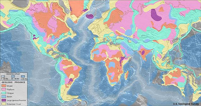
English: Map of world geologic provinces
Shield
Platform
Orogen
Basin
Large igneous province
Extended continental crust
Oceanic crust:
0–20 Ma
20–65 Ma
>65 Ma
These geologic province maps depict only features approximately 150 km across and greater due to the fact that the resolution of the maps should be consistent with the resolution of the seismic refraction data.
Source: http://earthquake.usgs.gov/research/structure/crust/maps.php ; original upload english wikipedia 22 April 2005 by SEWilcoLicensing
 |
This image is in the public domain because it contains materials that originally came from the United States Geological Survey, an agency of the United States Department of the Interior. For more information, see the official USGS copyright policy. български | català | Deutsch | English | español | eesti | suomi | français | galego | italiano | 한국어 | македонски | മലയാളം | Nederlands | polski | português | русский | Türkçe | 中文 | 中文(简体) | +/− |
|
File usage
The following pages on Schools Wikipedia link to this image (list may be incomplete):
Background information
SOS Children chose the best bits of Wikipedia to help you learn. SOS Children helps more than 2 million people across 133 countries around the world. Sponsoring a child is a great way to help children who need your support.