
File:Zambezi Barotse floodplain.jpg
Size of this preview: 271 × 479 pixels.
| |
This is a file from the Wikimedia Commons. Information from its description page there is shown below.
Commons is a freely licensed media file repository. You can help. |
Summary
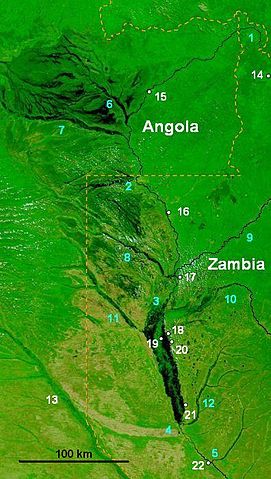
| Description | NASA false-colour image of the upper Zambezi and Barotse (Balozi) floodplain in extreme flood in 2003, water shows as dark areas. Blue numbers are rivers: 1 Zambezi source, 2 Zambezi at Chavuma Falls, 3 at start of Barotse Floodplain, 4 at end of the floodplain at the Kalongola Ferry, 5 at Ngonye Falls. Tributaries: 6 Chifumage, 7 Luena, 8 Lungwebungu, 9 Kabompo, 10 Luampa, 11 Luanguinga, 12 Lui, 13 Cuando. Towns (white numbers): 14 Mwinilunga, 15 Cazombo, 16 Zambezi, 17 Lukulu, 18 Limulunga, 19 Lealui, 20 Mongu, 21 Senanga, 22 Sioma.. |
| Date | 15 March 2007 |
| Source | Base is NASA image in public domain NASA: "Visible Earth" website accessed 1 March 2007 Credit: Jacques Descloitres, MODIS Rapid Response Team, NASA/GSFC. |
| Author | Rexparry_Sydney added overlay of labels/Symbols |
| Permission ( Reusing this file) |
See NASA terms of use on website above |
Licensing
|

File usage
The following pages on Schools Wikipedia link to this image (list may be incomplete):
A background to Schools Wikipedia
SOS Children aims to make Wikipedia suitable for young learners. SOS Childrens Villages helps more than 2 million people across 133 countries around the world. There are many ways to help with SOS Children's Villages.