
File:Topographic map of Greenland bedrock.jpg
Size of this preview: 369 × 479 pixels.
| |
This is a file from the Wikimedia Commons. Information from its description page there is shown below.
Commons is a freely licensed media file repository. You can help. |
Summary
| Description |
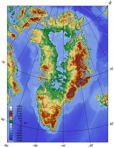
English: Topographic map of Greenland bedrock, in effect showing the topography without the extant ice sheet. Created using ETOPO1 Global Relief Model bedrock version from .
|
| Date | |
| Source | Own work |
| Author | Skew-t |
 |
This map image could be recreated using vector graphics as an SVG file. This has several advantages; see Commons:Media for cleanup for more information. If an SVG form of this image is already available, please upload it. After uploading an SVG, replace this template with {{ vector version available|new image name.svg}}. |
Licensing
|
File usage
The following pages on Schools Wikipedia link to this image (list may be incomplete):
Did you know...?
SOS Childrens Villages has brought Wikipedia to the classroom. SOS Children is there for the children in our care until they are ready for independence. Would you like to sponsor a child?