
File:Portugal topographic map-pt.png
| |
This is a file from the Wikimedia Commons. Information from its description page there is shown below.
Commons is a freely licensed media file repository. You can help. |
| Description |
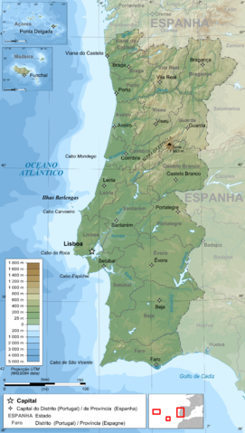
Français : Carte topographique et administrative en portugais du Portugal
Português: Carta topográfica e da administração do Portugal, em português
Deutsch: Topographische Karte von Portugal, portugiesische Version
English: Topographic and administrative map in Portuguese of Portugal
Español: Mapa topográfico y administrativo en portugés del Portugal
Italiano: Carta topografica e amministrativa de Portogallo
日本語: ポルトガル語で表示した ポルトガル地形·行政地図
|
||||||||
| Date | 14 June 2009 | ||||||||
| Source |
English: Own work ;
Français : Création personnelle ;
|
||||||||
| Author | Bourrichon - fr:Bourrichon | ||||||||
| Permission ( Reusing this file) |
|

This map was improved or created by the Wikigraphists of the Graphic Lab (fr). You can propose images to clean up, improve, create or translate as well.
বাংলা | català | česky | Deutsch | Deutsch (Sie-Form) | Ελληνικά | English | Esperanto | español | suomi | français | עברית | magyar | Հայերեն | italiano | 한국어 | македонски | Bahasa Melayu | Plattdüütsch | Nederlands | occitan | polski | português | română | русский | slovenščina | svenska | татарча/tatarça | Türkçe | українська | 中文 | 中文(简体) | 中文(繁體) | Zazaki | +/−
File usage
Learn more about Schools Wikipedia
You can learn about nearly 6,000 different topics on Schools Wikipedia. SOS Childrens Villages helps those who have nothing and no one, giving them back the famly they have lost and bringing them the very best opportunities for a happy, healthy future. Would you like to sponsor a child?