
File:Usgs map azimuthal equidistant.PNG
Usgs_map_azimuthal_equidistant.PNG (487 × 162 pixels, file size: 46 KB, MIME type: image/png)
| |
This is a file from the Wikimedia Commons. Information from its description page there is shown below.
Commons is a freely licensed media file repository. You can help. |
-
- (see below: Enlarged view)
Summary
| Description |
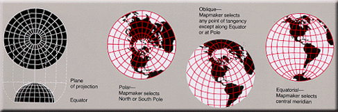
English: Condensed explanation of azimuthal-equidistant projection maps, colored as smaller PNG image, from larger, wider USGS file of GIF format. See enlarged view below, using a wikitable to expand beyond original size.
|
| Date | 17 February 2005 |
| Source | derivative from USGS image file (with map sections colored red/white),
|
| Author | User:Quadell, re-coloring US Government USGS image. |
 |
This map image could be recreated using vector graphics as an SVG file. This has several advantages; see Commons:Media for cleanup for more information. If an SVG form of this image is already available, please upload it. After uploading an SVG, replace this template with {{ vector version available|new image name.svg}}. |
Enlarged view
| Explanation of azimuthal-equidistant projection. |
Licensing
 |
I, the copyright holder of this work, release this work into the public domain. This applies worldwide. In some countries this may not be legally possible; if so: I grant anyone the right to use this work for any purpose, without any conditions, unless such conditions are required by law.
|
|
This image is in the public domain because it contains materials that originally came from the United States Geological Survey, an agency of the United States Department of the Interior. For more information, see the official USGS copyright policy. български | català | Deutsch | English | español | eesti | suomi | français | galego | italiano | 한국어 | македонски | മലയാളം | Nederlands | polski | português | русский | Türkçe | 中文 | 中文(简体) | +/− |
|
File usage
The following pages on Schools Wikipedia link to this image (list may be incomplete):
More information
All five editions of Schools Wikipedia were compiled by SOS Children's Villages. The world's largest orphan charity, SOS Children brings a better life to more than 2 million people in 133 countries around the globe. Sponsoring a child is the coolest way to help.